iFly GPS Forum

We have a new Forum!  Go here to get started: https://adventurepilot.community.forum.  
The new forum is easier to use and much more capable than the old, we hope you will join our community! 

Below is a copy of the old forum. This will remain available for a short period so you can access and review the information contained here. To continue a conversation, or start a new one, please register and create a post at our new forum location.
HomeHomeDiscussionsDiscussionsiFly Wish-ListiFly Wish-Listaltitude constraints for EACH waypointaltitude constraints for EACH waypoint
Previous
 
Next
New Post
4/13/2015 12:58 PM
 
This is very useful in IFR flight you are often cleared "descend 5000ft, level 10nm before WXYZZ". Or, you may wish to plan a descent to a certain altitude for an approach.

This might work on the Flight Plan page, with two fields available to input an altitude, and a distance before/after, for each waypoint. The airport would populate with the default settings you have now, but would be editable from this page. A VSR would be generated based on the NEXT upcoming altitude constraint in the flight plan.

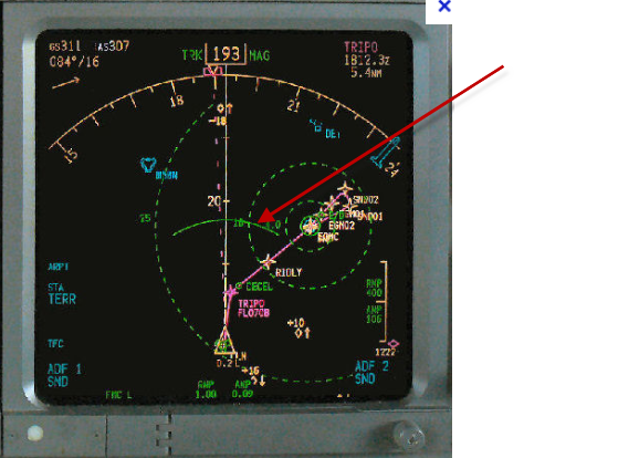
Now, if you want to really dress this feature up, add a Boeing Banana. This is a 20 deg arc that is drawn on the map, along the flight path, at point where you will cross the next altitude constraint given your current VS.


* Orest
 
New Post
4/13/2015 4:52 PM
 

Orest,

This is how I would do that today with iFly GPS: First insert a waypoint where you need to reach your altitude. In your example, I would use the Dynamic Distance Ring to find the exact point - first pan to WXYZZ, then back off 10 miles, then touch where the arc cross your flight plan, on the Nav tab touch Flight Planning, then "Insert as Waypoint".

Then touch the newly created Waypoint, again on the Nav tab select Flight Planning then Set Flight Altitude. (Check "Enable Multiple Flight Altitudes" checkbox if it's not), use the "Raise" / "Lower" to set your desired altitude. (You can hold your finger down on those buttons)

Once you have a specific altitude defined, a "VST" (Vertical Speed to Target) instrument will show up in your stack. This shows your required rate of climb/descent to reach your next planned altitude.

-Walter


Walter Boyd
President, Adventure Pilot
 
New Post
4/13/2015 6:21 PM
 
Ah, very good, hadn't found that option. Sorry about that.

Next the Boeing Banana!

* Orest
 
New Post
4/18/2015 10:59 PM
 
Everywhere Orest goes, he brings the Boeing Banana along. :-) Welcome to iFly, Orest!
 
New Post
4/22/2015 11:28 AM
 
And as I've asked for before in these pages (I think), instead of - or in addition to - the VST box, I'd like the option to paint a Glide Slope-like pointer on the side of the map (like my real HSI) that tells me if I'm "on course" vertically for my user entered climb or descent rate.

But I'd put that wish way down the list, after you've implemented my remaining wishes.
 
Previous
 
Next
HomeHomeDiscussionsDiscussionsiFly Wish-ListiFly Wish-Listaltitude constraints for EACH waypointaltitude constraints for EACH waypoint